Wednesday, March 18, 2009

One to Many Joins


This is one to many joins as many records in the layer's attribute table join to the same record in the table of soil type descriptions.

Joining Two Existing Tables


The exercise uses the table operations in ArcGIS. It uses the joins and relates for joining two tabular data files. It combines the demographic table to the mapped data in the block group layer. This is one to one join.

Monday, March 2, 2009

Manipulating Digital Data, NWI and DEM data


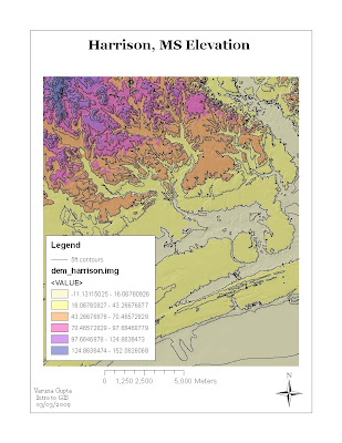
The above map is DEM with contour lines and hillshade. This exercise involved the manipuating of USGS 10 m DEM for study area ,Harrison. It used Spatial Analysis Extension.
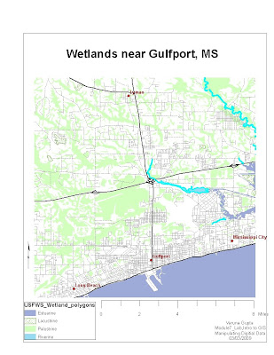

The map is the outcome of operations performed on the digital data obtained from the National wetland Inventory (NWI) developed by U.S Fish and Wildlife services. The map displays the wetlands and deepwaters habitats classification system. The exercise involved creating of new field in the attribute data, editing and reclass wetland system which is more easily interpreted.

Thursday, February 26, 2009

DO Rates_GPS sample points


It is a graduated quantity map indicating the dissolved oxygen rates in Escambia County, Florida. The spatial data for the county and GPS sample data points is used for creating the map. GPS samples data points (file saved as .csv) are imported as table as X,Y data in ArcGIS and converted into a feature class.

Tuesday, January 27, 2009


Mississipi Map is projected using three different projections. In addition, the comparison of these maps are done by calculating the areas of the three maps. Editor toolbar is used in the process for calculating areas.
The different projections not only have different absolute areas but also the general shape of the state changes with each projection.

Thursday, January 22, 2009

Wetlands for the Gulf Coast near Biloxi, MS

The map indicates the types of wetlands in Gulf coast surrounding Biloxi in Mississippi.

Base map for Hattiesburg, Mississippi